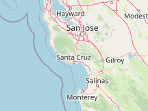
Please Select a Nearby Airport or Weather StationHere is a list of the nearby weather stations showing what historical data we have available for them. The available report types are color coded like so:
Watsonville Municipal Airport, United States
mostly cloudy @ 9:32 AM (5 min ago)
Norman Y. Mineta San José International Airport, United States
58°F, mostly clear @ 8:53 AM (44 min ago)
Reid-Hillview of Santa Clara County Airport, United States
57°F, mostly clear @ 8:47 AM (50 min ago)
Moffett Federal Airfield, United States
57°F, clear @ 9:15 AM (22 min ago)
Monterey Regional Airport, United States
54°F, overcast @ 8:54 AM (43 min ago)
San Carlos Airport, United States
55°F, clear @ 8:47 AM (50 min ago)
Salinas Municipal Airport, United States
55°F, overcast @ 8:53 AM (44 min ago)
Hollister Municipal Airport, United States
55°F, mostly cloudy @ 9:35 AM (2 min ago)
Half Moon Bay Airport, United States
54°F, mostly cloudy, mist @ 9:15 AM (22 min ago)
Hayward Air Terminal Airport, United States
56°F, partly cloudy @ 8:54 AM (43 min ago)
METAR ReportsAirport weather stations throughout the world routinely issue METAR weather reports . Such reports are used by pilots, air traffic controllers, meteorologists, climatologists, and other researchers. They are published via radio transmission and on the internet. We have been collecting and archiving published METAR reports since 2011, and have found third-party sources for archived reports from years prior to that. ISD ReportsThe Integrated Surface Database (ISD), maintained and published by NOAA's National Center for Environmental Information , consists of hourly and synoptic weather reports from a variety of sources. We use ISD data to complement and backfill for our METAR archive. |