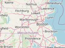
Please Select a Nearby Airport or Weather StationHere is a list of the nearby weather stations showing what historical data we have available for them. The available report types are color coded like so:
Norwood Memorial Airport, United States
64°F, clear @ 7:53 PM (35 min ago)
Lawrence G Hanscom Field, United States
67°F, mostly clear @ 7:51 PM (37 min ago)
East Milton, United States
16 mi east, 1998 - 2021
Logan International Airport, United States
64°F, overcast, precipitation: 0.00 in @ 7:54 PM (34 min ago)
Worcester, Worcester Regional Airport; United States
63°F, overcast, precipitation: 0.00 in @ 7:54 PM (34 min ago)
North Central State Airport, United States
56°F, overcast, light rain, precipitation: 0.00 in @ 7:56 PM (32 min ago)
Fitchburg Municipal Airport, United States
68°F, clear @ 7:52 PM (36 min ago)
Beverly Municipal Airport, United States
57°F, mostly cloudy @ 7:53 PM (35 min ago)
Lawrence Municipal Airport, United States
67°F, mostly cloudy @ 7:54 PM (34 min ago)
Cranland Airport, United States
34 mi southeast, 1946 - 1996
METAR ReportsAirport weather stations throughout the world routinely issue METAR weather reports . Such reports are used by pilots, air traffic controllers, meteorologists, climatologists, and other researchers. They are published via radio transmission and on the internet. We have been collecting and archiving published METAR reports since 2011, and have found third-party sources for archived reports from years prior to that. ISD ReportsThe Integrated Surface Database (ISD), maintained and published by NOAA's National Center for Environmental Information , consists of hourly and synoptic weather reports from a variety of sources. We use ISD data to complement and backfill for our METAR archive. |